DeepSeek与ArcGIS深度融合智能地名地址查询与三维可视化实践
·
一、引言:当大语言模型遇上地理信息系统
在AI技术飞速发展的今天,大型语言模型(LLM)如DeepSeek已经具备了调用外部工具的能力,而ArcGIS作为业界领先的地理信息系统平台,提供了强大的空间数据可视化与分析功能。本文将介绍如何将DeepSeek的工具调用能力与ArcGIS相结合,构建一个智能地名地址查询与三维可视化系统。
二、技术架构设计
1. 系统整体架构
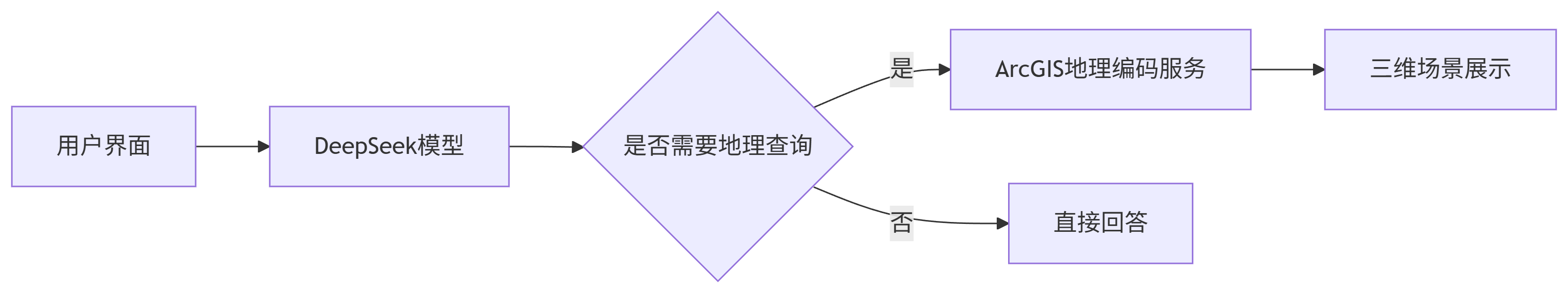
2. 关键技术组件
-
DeepSeek模型:负责自然语言理解与工具调用决策
-
ArcGIS API for JavaScript:提供地图展示与地理编码能力
-
SceneView:三维场景渲染引擎
-
Locator:地理编码服务接口
三、核心功能实现
1. 工具定义与注册
在DeepSeek中注册ArcGIS地理查询工具:
const arcgisTool = {
  type: 'function',
  function: {
    name: 'query_arcgis_location',
    description: '查询指定地名的经纬度坐标和详细信息',
    parameters: {
      type: 'object',
      properties: {
        location: {
          type: 'string',
          description: '要查询的地名或地址,如"北京市朝阳区"'
        }
      },
      required: ['location']
    }
  }
};
2. ArcGIS三维场景初始化
const map = new Map({
  basemap: "dark-gray-vector",
  ground: "world-elevation"
});

const view = new SceneView({
  container: "viewDiv",
  map: map,
  camera: {
    position: [116.4, 39.9, 10000], // 初始视角定位
    tilt: 45,
    heading: 0
  }
});
3. 地理编码服务集成
const locator = new Locator({
  url: "https://geocode.arcgis.com/arcgis/rest/services/World/GeocodeServer"
});

async function queryLocation(location) {
  const results = await locator.addressToLocations({
    address: { "SingleLine": location },
    outFields: ["*"]
  });

  if (results.length > 0) {
    return {
      location: results[0].address,
      coordinates: [results[0].location.x, results[0].location.y],
      attributes: results[0].attributes
    };
  }
  return null;
}
4. DeepSeek工具调用处理
async function processToolCall(toolCall) {
  const toolName = toolCall.function.name;
  const args = JSON.parse(toolCall.function.arguments);

  switch (toolName) {
    case 'query_arcgis_location':
      const result = await queryLocation(args.location);
      if (result) {
        // 在ArcGIS场景中添加标记
        addMarkerToScene(result.coordinates, result.location);
        return result;
      }
      return { error: "未找到指定位置" };
    // 其他工具处理...
  }
}
四、关键技术实现细节
1. 流式交互处理
async function callDeepSeekWithArcGIS(messages) {
  await callDeepSeekWithToolsStream(messages, [arcgisTool], (data) => {
    if (data.choices?.[0]?.delta?.tool_calls) {
      // 处理工具调用请求
    } else if (data.choices?.[0]?.delta?.content) {
      // 实时更新回答内容
    }
  });
}
2. 三维场景标记添加
function addMarkerToScene(coords, title) {
  const point = new Point({
    longitude: coords[0],
    latitude: coords[1]
  });

  const markerSymbol = new SimpleMarkerSymbol({
    color: [255, 0, 0],
    outline: { color: [255, 255, 255], width: 2 }
  });

  const graphic = new Graphic({
    geometry: point,
    symbol: markerSymbol,
    popupTemplate: {
      title: title,
      content: "坐标: " + coords.join(", ")
    }
  });

  view.graphics.add(graphic);
  view.goTo({ target: point, zoom: 12 });
}
3. 用户界面优化
/* 三维场景容器 */
#viewDiv {
  height: 500px;
  width: 100%;
  border-radius: 8px;
  margin-top: 20px;
}

/* 搜索结果弹窗 */
.esri-popup {
  font-family: 'Arial', sans-serif;
}

/* 标记点动画 */
@keyframes pulse {
  0% { transform: scale(1); }
  50% { transform: scale(1.2); }
  100% { transform: scale(1); }
}

.esri-icon-map-pin {
  animation: pulse 1.5s infinite;
}
五、应用场景与效果展示
1. 典型使用流程
-
用户输入:"显示上海东方明珠的三维地图"
-
DeepSeek识别地理查询意图
-
调用ArcGIS地理编码服务获取坐标
-
在三维场景中定位并高亮显示
-
返回文字描述:"已为您定位到上海东方明珠的坐标"
用户:我想看看上海东方明珠附近的三维地图

DeepSeek:
正在查询上海东方明珠的位置...
[调用query_arcgis_location工具]
已找到上海东方明珠,坐标121.4997, 31.2397
[三维场景自动旋转并定位到目标位置]
这是上海东方明珠的三维视图,高度468米...
六、技术扩展方向
1. 增强查询能力
// 周边搜索扩展
const nearbySearchTool = {
  //...
  parameters: {
    location: { type: "string" },
    radius: { type: "number", description: "搜索半径(米)" },
    category: { type: "string", description: "POI类别" }
  }
};
2. 空间分析集成
// 视域分析示例
function performViewshedAnalysis(coords) {
  const viewshed = new Viewshed({
    positions: [new Point({ x: coords[0], y: coords[1], z: 100 })],
    range: 5000
  });
  //...
}
3. 多数据源融合
// 接入WMS服务
const wmsLayer = new WMSLayer({
  url: "https://gis.example.com/wms",
  sublayers: [{ name: "landuse" }]
});
map.add(wmsLayer);
七、总结与展望
本文介绍的DeepSeek与ArcGIS集成方案具有以下优势:
-
自然交互:用户可以使用自然语言进行地理查询
-
智能决策:模型自动判断何时需要调用地理服务
-
直观展示:查询结果通过三维场景直观呈现
-
扩展性强:可轻松集成更多空间分析功能
未来可进一步探索:
-
结合AR技术实现混合现实展示
-
接入实时交通、气象等动态数据
-
开发专业领域的空间智能分析工具
这种AI与GIS的深度融合,将为智慧城市、应急管理、商业分析等领域带来全新的应用体验。

欢迎加入DeepSeek 技术社区。在这里,你可以找到志同道合的朋友,共同探索AI技术的奥秘。
更多推荐


 3
3 0
0- 0


 已为社区贡献1条内容

所有评论(0)